


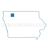
WATERFORD TWP Voting District, Clay County, Iowa
About
Outline

Summary
| Unique Area Identifier | 581806 |
| Name | WATERFORD TWP Voting District |
| County | Clay County |
| State | Iowa |
| Area (square miles) | 35.61 |
| Land Area (square miles) | 35.50 |
| Water Area (square miles) | 0.11 |
| % of Land Area | 99.69 |
| % of Water Area | 0.31 |
| Latitude of the Internal Point | 43.20536570 |
| Longtitude of the Internal Point | -95.31874990 |
Maps

Graphs
Select a template below for downloading or customizing gragh for WATERFORD TWP Voting District, Clay County, Iowa


Neighbors
Neighoring Voting District (by Name) Neighboring Voting District on the Map
- EVERLY Voting District, Clay County, IA
- HARRISON TWP Voting District, Osceola County, IA
- HARTLEY TWP W/O HARTLEY Voting District, O'Brien County, IA
- LONE TREE TWP W/O EVERLY Voting District, Clay County, IA
- OKOBOJI TWP W/O MILFORD & WEST OKOBOJI Voting District, Dickinson County, IA
- OMEGA TWP Voting District, O'Brien County, IA
- RIVERTON TWP PART Voting District, Clay County, IA
- SUMMIT TWP Voting District, Clay County, IA
- WESTPORT TWP Voting District, Dickinson County, IA
Top 10 Neighboring County Subdivision (by Population) Neighboring County Subdivision on the Map
- Okoboji township, Dickinson County, IA (2,233)
- Hartley township, O'Brien County, IA (1,869)
- Lone Tree township, Clay County, IA (792)
- Summit township, Clay County, IA (494)
- Riverton township, Clay County, IA (277)
- Harrison township, Osceola County, IA (245)
- Omega township, O'Brien County, IA (223)
- Waterford township, Clay County, IA (200)
- Westport township, Dickinson County, IA (110)
Top 10 Neighboring Place (by Population) Neighboring Place on the Map
Top 10 Neighboring Unified School District (by Population) Neighboring Unified School District on the Map
- Okoboji Community School District, IA (6,831)
- Hartley-Melvin-Sanborn Community School District, IA (4,601)
- Clay Central-Everly Community School District, IA (2,301)
Top 10 Neighboring State Legislative District Lower Chamber (by Population) Neighboring State Legislative District Lower Chamber on the Map
Top 10 Neighboring State Legislative District Upper Chamber (by Population) Neighboring State Legislative District Upper Chamber on the Map
Top 10 Neighboring 111th Congressional District (by Population) Neighboring 111th Congressional District on the Map
Top 10 Neighboring Census Tract (by Population) Neighboring Census Tract on the Map
- Census Tract 804, Clay County, IA (3,109)
- Census Tract 4602, Osceola County, IA (2,930)
- Census Tract 4901, O'Brien County, IA (2,860)
- Census Tract 4502, Dickinson County, IA (2,180)